
UCAP investigations in autumn 2013
By Tim Skuldbøl and Carlo Colantoni
Aims of investigations
The University of Copenhagen’s Archaeological Project on the Rania Plain (since autumn 2015 the Danish Archaeological Expedition to Iraq) resumed in late autumn 2013 between 5th October and 7th November 2013.
The aims were to investigate remains of early urban societies on the Rania Plain, to continue archaeological salvage operations at the twin sites of Bab‐w‐Kur (see Part 1 below), and to begin a survey on the Rania Plain in collaboration with the Netherlands Institute for the Near East - NINO (see Part 2).
In 2013 the University of Copenhagen team consisted of Tim Skuldbøl (Director), Carlo Colantoni, Rasmus Birk, Henrik Brahe, Guenever Bjerre Thaarup, Jill Weber and was kindly assisted by Barzan Baiz (Museum representative).
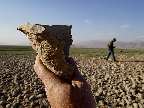
Figure 1. Surface inspection at Bab‐w‐Kur, 2013 (Photo: Henrik Brahe 2013)
Part 1 - Archaeological investigations at Bab-w-Kur
In 2013 the high water levels of Lake Dokan made it difficult to continue our investigations at the main mound of Bab, the largest of the twin Bab‐w‐Kur mounds. Consequently, we began investigations of the smaller mound of Kur (Figure 1). At opportune moments, small and supplementary investigations were conducted on Bab with the help of a local fishing boat and in the final days of the field season when Bab and Kur, due to the receding of the lake waters, were no longer separated by water.
Investigations in 2013 comprised of:
A) Photographic recording of surface remains at Bab‐w‐Kur and selected sites.
B) Topographical investigations and observations at Bab‐w‐Kur.
C) Excavation and surface scraping at Kur.
A. Photographic recording of surface remains at Bab‐w‐Kur and selected sites
Photographic recording of surface remains exposed by the seasonal receding of water levels of Lake Dokan at Bab‐w‐Kur were conducted by Henrik Brahe, a Danish photographer and specialist in UAV photography.
At Bab the high‐water mark of the lake has removed archaeological features such as walls, kilns, and pots and yet undefined archaeological deposits since our last visit in the autumn of 2012. Nonetheless, we located a series of newly exposed large buildings on the southern slopes of the mound and the outline of a large monumental building was observed on the top of the mound.
Whilst at Kur the seasonal reduction in water levels of Lake Dokan exposed numerous garbage pits that contained abundant ceramic material dating to the Late Chalcolithic 4 and 5 periods (Figure 2).
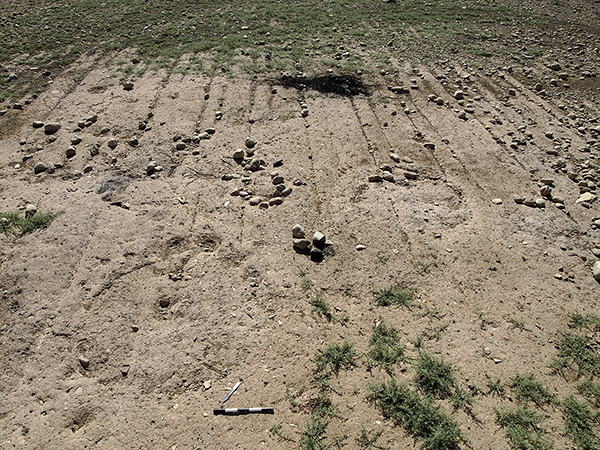
Figure 2. The numerous garbage pits observed on the surface of Kur (Photo: Henrik Brahe 2013).
With the help of an UAV/drone the surface of Bab‐w‐Kur and its surroundings, as well as the sites Lower Warankah and Basmusian, were photographed (Figure 3 and 4). The recorded archaeological features will probably be lost to continuing erosion by the lake’s waters.
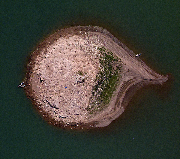
Figure 3. UAV/Drone photo of the main mound Bab (Photo: Henrik Brahe 2013)
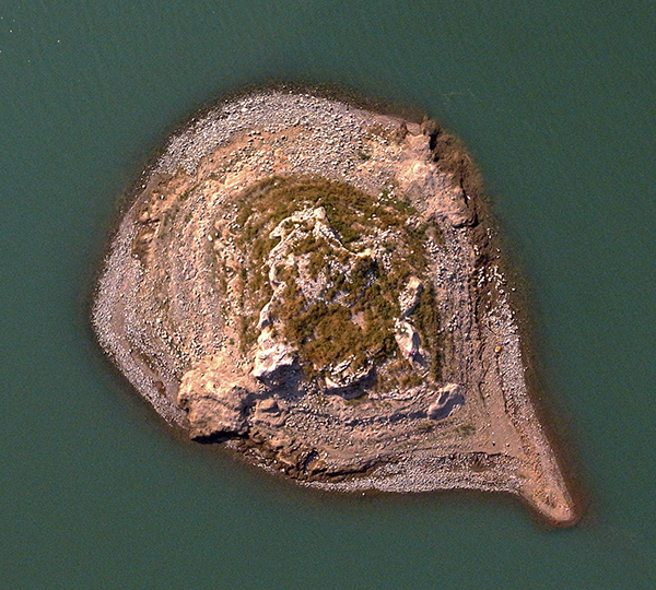
Figure 4. UAV/Drone photo of Basmusian (Photo: Henrik Brahe 2013)
B. Topographical investigations and observations at Bab‐w‐Kur
The topographical map of Bab‐w‐Kur, which was initiated in 2012, was in 2013 extended to include the site of Kur as well as a series of subsidiary mounds clustering around Kur. It is apparent that when compared with CORONA satellite imagery the site of Bab‐w‐Kur makes up a complex of two main sites and numerous small subsidiary sites (Figure 5).
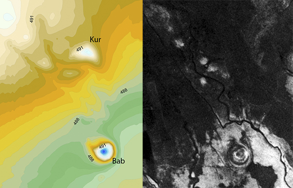
Figure 5. Topographical map of Bab‐w‐Kur and CORONA Satellite image of the Bab‐w‐Kur cluster (Illustration: Tim Skuldbøl 2013).
Although Kur is a low mound of about three meters in height it has suffered considerably from the inundation of the Lake Dokan. Large deposits of washed and displaced potsherds are found in several locations on the site. During the 2013 excavations it also became clear that the shape of Kur has changed significantly with large deposits of lake material deposited on the top and northern side of the mound.
C. Excavation and surface scraping at Kur
Excavations at Kur began with a 10x10m trench (Trench 1) on the top and a scrape area of 20x40 m on the eastern slope of the mound. Small soundings (2x2m) were also excavated on the satellite mounds around Kur.
Trench 1 produced a series of garbage deposits ‐ most probably representing frequent garbage disposal events and pitting at Kur. They consisted mainly of Southern middle‐late Uruk pottery (e.g. Beveled Rim Bowls and jars with straight spouts) (Figure 6).
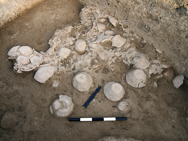
Figure 6. Level 1 garbage deposits in Trench 1 (Photo: Henrik Brahe 2013)
In the scrape area on the eastern slope of Kur a series of garbage pits were defined.
Excavation was extended with two additional trenches (Trench 2 and 3). Both produced remains of large garbage pits (Level 1) that cut into earlier levels.
In Level 2 a large monumental and niched building was recovered (Figure 7). The building was solidly built and was decorated with niches and white‐plastered walls. These traits are traditionally associated with religious institutions throughout Mesopotamian history and it is therefore assumed that this building had ritual or administrative functions. Parallels are to found at Arslantepe in Turkey and Tell Brak in Syria, whilst fleeting similarities are visible in large Level IX and VIIIC structures at Tepe Gawra.
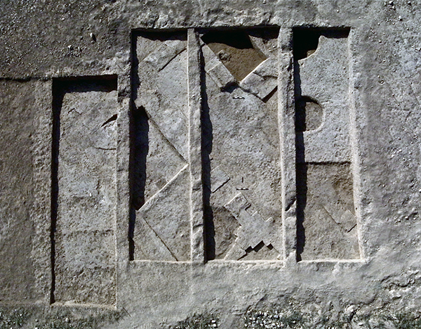
Figure 7. Kur, Level 2. Niched building. 0.5m scale (Photo: Henrik Brahe 2013).
Unfortunately, only two rooms were partly explored within this building. In one room a large jar dating to the Late Chalcolithic 3 (ca. 3800‐3600 BC) that had fallen into the doorway from a nearby pedestal was recovered. From the other room we recovered a stamp seal depicting felines (possibly lions) arranged in a circular pattern – a motif that is common in Upper Mesopotamia in the LC 3‐4 period (Figure 8).
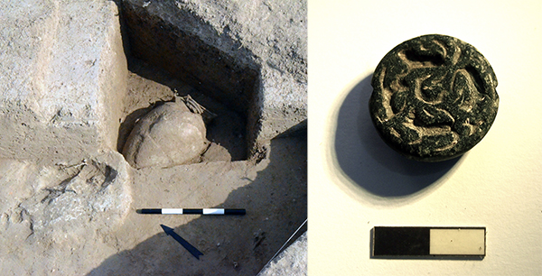
Figure 8. Kur, Level 2. Water jar in doorway of the ‘Niched building’ and stamp seal (Photos: Tim Skuldbøl and Henrik Brahe 2013).
PART 2 - The Rania Plain Survey Project
This project was initiated in late 2013 in collaboration with NINO as a follow up to the salvage excavations conducted at Shemshara and Bab‐w‐Kur. The initial aims of the survey are twofold: firstly to identify and record the archaeological sites in danger of destruction by the lake's waters and modern development, and secondly to place these and other settlements on the plain into a wider analysis of the development of settlement complexity on the fringes of the Mesopotamian heartlands (Figure 9).
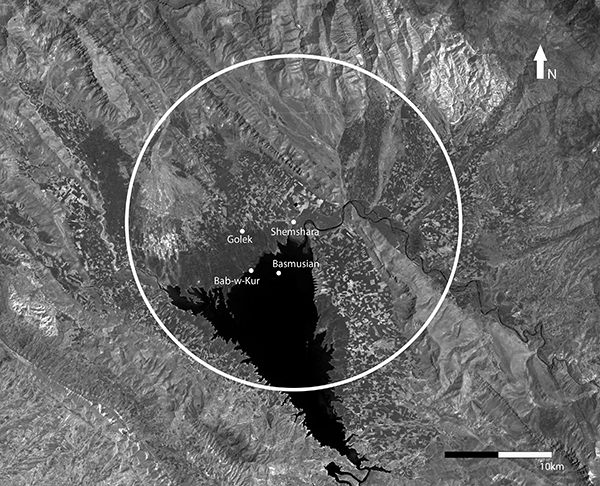
Figure 9. Landsat satellite image from 1999 showing the 15 km radius survey area around Shemshara (Illustration: Tim Skuldbøl).
Today the Rania Plain is an endangered archaeological landscape (see Skuldbøl and Colantoni 2014). In recent years there has been a huge growth in economic prosperity in Iraqi Kurdistan. This has brought rapid growth to the plain. The towns and villages are expanding and together with infrastructure development and the intensification of agricultural activities a serious threat to the rich archaeological heritage on the plain and in the wider region is emerging.
The plain’s many archaeological sites are heavily affected by pressure from a range of threats from expansive modern development, such as: extensive infrastructure development; large concrete works and factories in the modern towns of Chwarqurna and Rania; rapid expansion, and sprawl of towns and villages (Boskin, Chwarqurna and Rania); the intensification of destructive agricultural practices; and by the waters of the hydroelectric Dokan Dam’s reservoir: Lake Dokan.
There has been an intensification of agricultural activities on the Rania plain that particularly affects smaller, more ephemeral sites. Clearly visible across the plain is the growth of these destructive large‐scale agricultural practices: expanded fields with deep‐ploughing and irrigated crops, irrigation channels, and hundreds of large water‐capture reservoirs created with earth diggers and bulldozers (Figure 10).
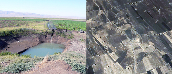
Figure 10. The impact of intensified agricultural activities (water reservoirs) in a section of the Rania Plain. A) Water reservoir (Photo: Carlo Colantoni 2013). B) World View 2 satellite image (Digital Globe 2010).
Tell Boskin, located in the middle of the modern town of Boskin, is a good example of a site being destroyed by modern urban expansion. Relatively intact in 1956, the site was a large mound 15m in height (Al‐Soof 1970). Today the site is in a sorry state with less than one hectare of the site not covered by modern construction. The top and sides of the mound have been levelled for a water‐pumping station. Numerous graves have also been dug into the flanks of the mound. As town houses encroach onto the mound deep, large pits have been created. These are now being expanded and filled with town garbage (Figure 11).
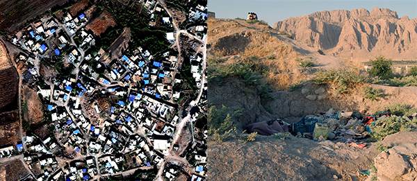
Figure 11. Damage to the ancient mound of Boskin. A) World View 2 satellite image (Digital Globe 2010). B) Photo: Tim B.B. Skuldbøl 2012.
These types of threats to archaeological sites are common across the Middle East. An unsusual, although not unique, additional factor in the accumulation of damage to the archaeological landscape of the plain is the Dokan Dam. Following the dam’s construction many archaeological sites in the southern half of the Rania Plain were flooded by its reservoir, Lake Dokan, and thus ‘sealed’. However, during the past few decades major fluctuations have been registered in the water level of the lake (see note 1). Many sites previously covered by the lake’s waters are now exposed to erosional processes as the water levels rise and fall within the annual inundation zone. This incessant action is a slow but tangible threat to the archaeological heritage lying within this zone.
The Dokan Dam inundation zone is an area along the northern shore of the lake, where the height of the water fluctuates according to season. Records show that between the spring and summer of 2000‐2010 the lake rose, on average, between 7 and 22 metres. During this decade the level of the lake varied as much as 32 metres. This annual rise and fall submerges many sites and erodes them due to wave action. It also partially obscures them by depositing silt. Evidence of erosional damage to intact archaeological deposits is visible at many sites located in this inundation zone.
Working in the inundation zone of the Lake Dokan
The Rania Plain in the vicinity of Lake Dokan is an unusual environment in which to survey. As the water recedes the landscape is often muddy and silty making working conditions challenging, but this does have the advantage of good visibility for the identification of surface sherds (Figure 12).
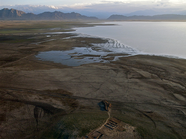
Figure 12. The Dokan Lake with Kur in the foreground (Photo: Henrik Brahe 2013).
Forming a basis of reference for the survey are a combination of very high‐resolution (0.5m panchromatic) WorldView images, open access BING and Google Maps, and older black and white CORONA images (which show the landscape of the plain from the late 1960s, well before recent economic prosperity led to major urban and infrastructure development). Unfortunately, the dam was constructed before the CORONA images were taken, so the southern half of the plain in these images lies under the lake. Hence insights into the previous unsubmerged landscape are not possible.
The University of Copenhagen chose a preliminary 2 by 2 km ‘test area’ roughly around the site of Kur and bound, to its east and west, by wadi and spring systems. The intention was to collect data within a discrete environmentally constrained zone. This focus allowed the tracking of the distribution of sites along the north‐south wadi systems that originally flowed southwards down the topographic decline of the plain towards where the Lesser Zab flowed in antiquity.
We chose an intensive test area because by sampling the density and constituent elements of the Bab‐w‐Kur settlement complex indications of the true complexity of the wider settlement landscape could be discerned. By intensive field walking the survey was able to record landscape features and settlements ambiguous or indistinguishable when examining satellite imagery, such as small, flat mounding; submerged sites; and possible settlement sprawl: potential off‐site activity areas and areas of trash dumping.
Adding to this approach was the use of drone photography (Figure 13).
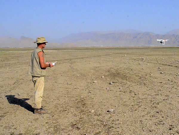
Figure 13. UAV/Drone photography (Photo: Tim Skuldbøl 2013)
The project employs a small remote‐control aerial drone equipped with a high‐resolution digital camera capable of flying up to an altitude of a couple of hundred metres. With this drone the survey has been able to record a series of highly detailed real‐time aerial images.
The project is developing this technique as a useful tool to monitor damage to the archaeological landscape with up‐to‐date photographic records and also as a means of identifying architecture and archaeological features visible on the surfaces of the mounds that have been scoured or washed clean by the action of the lake’s waters. As a tool for recording and monitoring archaeological heritage drones are a rapid and inexpensive resource.
Preliminary results of the Rania Plain Survey
During the survey in 2013 the project identified 33 sites of which 29 were collected. A number of these were known from surveys by Iraqi archaeologists, notably Al‐Soof, in the late 1950s before the flooding of the southern half of the plain. Al‐Soof appears to have focused on the most visible mounds in the landscape. However, during our survey a number of quite prominent mounds and many very low, small and hard to recognize sites were newly identified (Figure 14). It should be noted that the following results are preliminary as the dating of sites is still an ongoing process.

Figure 14. CORONA satellite image showing the distribution of sites in the 2013 survey test area (Illustration: Tim Skuldbøl. CORONA image 1967).
Preliminary examination of the material shows that there is a small number of Neolithic and early‐middle Chalcolithic sites belonging to the Hassuna, Halaf and Ubaid periods. There then appears to be a rapid growth in the Late Chalcolithic, with more than twenty sites dating to the Late Chalcolithic 2‐5 period, many of which with southern Uruk material (fourteen sites possess the distinctive Bevel Rim Bowl). To this number, we can add around twenty Uruk sites from across the Rania Plain accounted for by Al‐Soof (1968 and 1970). There is then a decline in settlement numbers for the subsequent periods. However, this may change as the processing and identification of material for the third, second and most of the first millennium BC is still an ongoing task. This possible decline appears to have been followed by a second peak in occupation in the Hellenistic through Seleucid, Parthian, Sassanian and Islamic periods.
In the test zone around Bab‐w‐Kur the survey shows that settlement was concentrated on the three wadi systems of which two lay either side of the Bab‐w‐Kur wadi system, with 10 sites strung along the western wadi system and 11 along the eastern. Investigations also suggest that in the sample area there is a complex settlement patterning with a clustering of small satellite sites (less than a hectare) around the sites of Bab and Kur. This complex consists of the two main sites and seven, so far identified, satellites (A‐G).
A number of soundings in the low mounding of these satellites produced large quantities of Late Chalcolithic 3‐4 period pottery. The project believes that they could either be areas of limited ‘off‐site’ occupation, off‐site activity areas or even the results of trash dumping.
Insights and future work on the Rania Plain
The survey work has so far provided a number of insights into the distribution of settlement across the plain: (1) the sites are distributed, unsurprisingly, along perennial water sources; (2) that many of the sites are relatively small at 0.5‐2 hectares; (3) that there a number of complexes made up of smaller sites; and (4) that the plain has surprisingly dense settlement patterns ‐ particularly in the Late Chalcolithic and in the Hellenistic through Islamic periods.
Survey and excavations around the twin mounds of Bab‐w‐Kur suggest that in the Late Chalcolithic period the site was a small secondary centre with production and administrative functions within a larger early urban settlement system on the Rania Plain (see Skuldbøl et al. 2014 - referenced in the publication section). In the Late Chalcolithic period we may be witnessing small satellite sites clustering along water systems and perhaps indicating the formation of an expansive zone of habitation related to a yet undetermined, larger nearby settlement.
This is still an ongoing investigation. The project intends to build on these insights in future research seasons.
The project plans to continue the survey along the shoreline of the lake. There is a need to assess the damage to the archaeological heritage on the Rania Plain by identifying sites and monitoring threats of damage by the erosion by the lake waters, intensification of agriculture and expanding modern urban development.
As the survey area is expanded new data providing a more comprehensive understanding of the development of the settlement patterns over time -especially issues of dispersal and nucleation‐, settlement density, the intensity of agricultural exploitation and issues of possible settlement coalescence on the plain will become more apparent (some of these issues have been discussed in various publications by Skuldbøl and Colantoni, see Publication section).
NOTES
1 From the study of CORONA satellite imagery, fluctuations in the water level of Lake Dokan seem also to occur in the 1960s through 1990s. Little data is currently available to evaluate the extent of the damage to archaeological sites resulting from these fluctuations.